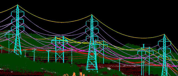
UTILITY MAPPING SERVICES
With more than 100000 km of experience in utility mapping services and Power Lines Maintenance (transmission and distribution) from LiDAR Data and Aerial Photography, InfoTech provides custom and high quality utility mapping solutions from LiDAR and imagery.
Through our extensive experience, we have developed our own processing and QA software to provide you better and faster results for 3D network design, vegetation management, clearance distances or PLS-CADD modelling among others.
* Quality Control and flight line adjustment
* LiDAR classification (by voltage and danger)
* 3D Network Modelling and 2D vectorization
* Vegetation management and clearance distances
* Quality Control of the results (precision 99,99%)
* Clearance distances and minimum distances analysis
* PLS-CADD modelling for different weather conditionsInteractive online Reports (GEO-links)