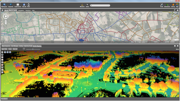
LiDAR is a surveying method that measures distance to a target by illuminating that target with a laser light. We at, InfoTech,
combines LiDAR with GIS data and other survey information to generate complex geomorphic structure mapping products, advanced 3D
models/earthwork profiles, rendering of structures, and many additional high value mapping products. InfoTech, offers variety of
services related to post processing of LiDAR point cloud data which includes BE (Bare earth) classification, utility classification,
topographic and land use classifications. We have been providing our technical services related to LiDAR to numerous customers around
the world for almost 6 years now. The technical services provided by InfoTech are very cost effective and qualitative which interns
provide a cutting edge to our customers among their competitors. We seamless integrate LiDAR data with other data sets, including
orthophotos imagery.
LiDAR Mapping Services
Fast and cost-effective LiDAR map outsourcing tailored to your budget and needs!
LiDAR is a surveying method that measures distance to a target by illuminating that target with a laser light. InfoTech Enterprises ranked among top LiDAR Mapping Companies in India for outsourcing services. We at, InfoTech, combines LiDAR with GIS data and other survey information to generate complex geomorphic structure mapping products, advanced 3D models/earthwork profiles, rendering of structures, and many additional high value mapping products. InfoTech, offers variety of services related to post processing of LiDAR point cloud data which includes BE (Bare earth) classification, utility classification, topographic and land use classifications.
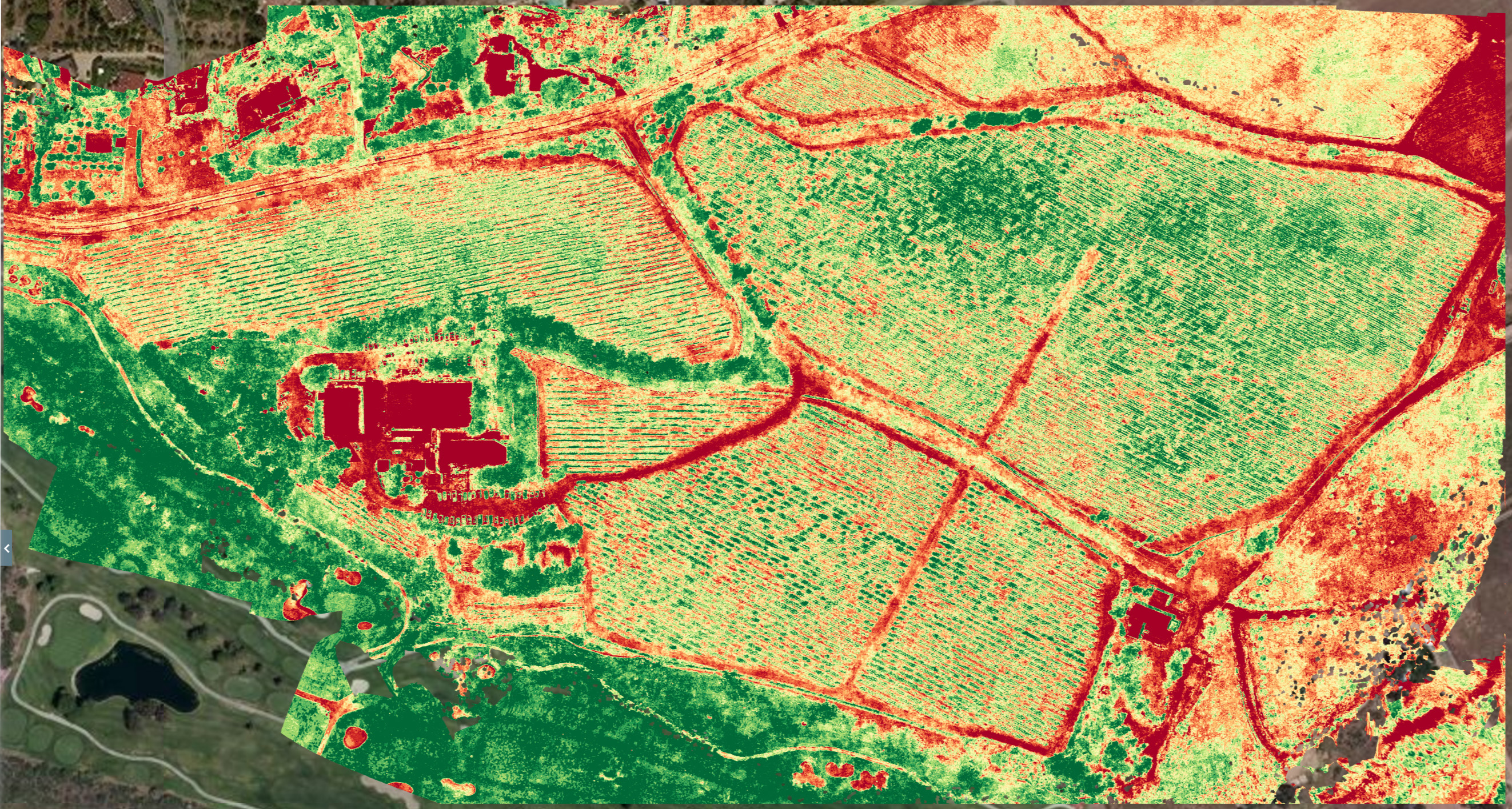
InfoTech outsourced mapping services include mapping from Light Detection and Ranging (LiDAR) survey data. Both ground and aerial LiDAR data can be integrated. Aerial data gathered in this way uses laser reflection from the earth's surface captured by sensors in an aircraft. This allows the precise elevation and location of objects to be determined on different scales, making aerial LiDAR an effective approach for creating accurate topographical maps.
The same data also allows the production of planimetric maps, slope/aspect views, DEM (digital elevation models), DTM (digital terrain models) and DSM (digital surface models). This makes it particularly well-adapted to forestry, oceanography and emergency management map applications. Aviation safety and coastal erosion mapping also benefit.
InfoTech Enterprises - LiDAR Mapping company in India
InfoTech puts the power of specialist LiDAR map automation systems at your disposal. We keep pace with LiDAR innovations such as multiple intensity returns and increased pulse repetition rates to produce increasingly accurate and cost-effective maps and images. We can also combine LiDAR with other survey data and GIS input to produce geomorphically-oriented mapping and imaging, as well as advanced 3D models.
Floodplain mapping, with flood hazard prediction, hydrology and hydraulic mapping
Forest inventory for tree heights, timber and biomass volumetric calculations
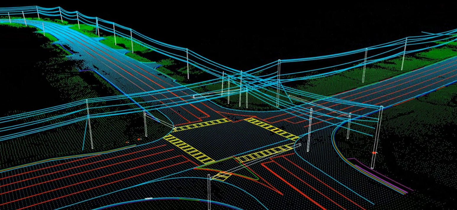
Transport and Utility corridor mapping
3D construction and urban modeling
Land-use (socio-economic activity/activities) and land-cover (grass, asphalt, trees, bare ground, water, etc.) classification
Advantages of Our LiDAR Mapping Services
Fast turnaround on maps and other LiDAR derived mapping deliverables to make the most of rapid LiDAR data gathering
Accurate production of ortho-rectified DEMs from LiDAR data
Variety of bare earth output formats including ASCII, CAD, ESRI and LAS
Accelerated LiDAR data processing for speedy bare earth maps and automated 3D breaklines
Flexible integration of LiDAR data with digital orthophotos, and multispectral, hyperspectral and panchromatic (black and white) imagery
Reliable generation of 3D models and volumetric determination
Optimized LiDAR point cloud densities according to desired accuracy, speed and budget levels
Outsource LiDAR Mapping and Related Services to InfoTech Enterprises Company
Unlike aerial photography that depends on fine weather conditions to be useful, good quality LiDAR data collection can also be done in sub-optimal (including cloudy) conditions. InfoTech experts work with survey crews to determine the detail and density to be achieved. If your project has tight deadlines, but simply requires good rather than ultimate quality levels, a matching level of survey and processing criteria can save on processing and personnel resources. That means you can get the result you need faster and at lower cost. Infotech known for its quality delivery of services and which made it one of the fast growing LiDAR mapping companies in India. Our mapping engineers and technicians work with you to make sure that each LiDAR mapping solution is right-sized for optimal return on investment and successful projects.
We have been providing our technical services related to LiDAR to numerous customers around the world for almost 6 years now. The technical services provided by InfoTech are very cost effective and qualitative which interns provide a cutting edge to our customers among their competitors. We seamless integrate LiDAR data with other data sets, including orthophotos imagery.
To outsource LiDAR mapping services to InfoTech, contact us at info@infotechit.net