InfoTech’s Cadastral GIS applications, while not as glamorous as GIS applications for emergency response or law enforcement, enhance the performance of the assessor's office and often provide the foundation for the development of GIS throughout a local government.
Cadastral data defines the geographic extent of the past, current, and future rights and interests in real property and the spatial information needed to describe that geographic extent. These rights and interests are contained in land record documents.
The cadastral data for a county, known as the tax assessment role, is maintained by the county assessor's office. Assessors do not determine tax rates, nor do they collect or figure taxes-they value real property for taxation purposes. This ensures the equitable distribution of a community's tax burden.
Property taxes are the major source of revenue that allows local governments to provide community services such as fire and police protection. The quality of the work performed by this office directly impacts the financial security of a community.
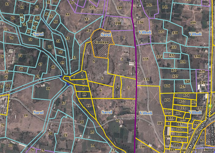
Tax maps were originally drawn by hand on Mylar or linen. These maps were difficult to keep up-to-date and cumbersome to store and retrieve. Multiple copies of maps sometimes contained different or conflicting information. Tax maps maintained as part of a GIS are more easily updated, organized, and shared across departments in a local government. Parcels can be linked to data stored in a Computer Assisted Mass Appraisal (CAMA) system, a widely used system for storing tabular information on real property.
Working Better and Smarter
GIS also benefits assessors by improving the quality of valuations. More factors relating to each property can be considered when determining value. Instead of hunting through paper maps or searching CAD documents, an assessor can query and not only find the parcel immediately but also access related information that previously was kept in separate tabular databases or in filing cabinets. Square footage and acreage calculations can be performed on the fly.
"Location, location, location," the mantra of real estate agents, holds true for assessors as well. Knowing the location of the subject property in relation to factors such as flood zones or water frontage improves valuation. By querying the GIS, assessors can identify all properties with similar use codes, sizes, locations, or other features that affect value in a specified area.
GIS is also a tool for working smarter. Thematic mapping makes it easy to spot such things as disparities between selling prices and assessed values or missed assessments. Land and building values can also be analyzed by neighborhood to help identify areas of concern. Homogeneous areas can be identified so that mass appraisal techniques can be used to streamline work.
Working smarter extends to the management aspects of running an assessor's office. GIS can help manage personnel and chart work flow.