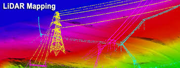
LiDAR is also known as Light Detection and Ranging. LiDAR technology uses light sensors to measure the distance between the sensor and the target object. LiDAR is a remote sensing method that uses laser to measure the elevation like the ground, forest, and buildings.
It uses the ultraviolet, visible, or near-infrared source to sense objects. Light energy emitted by LiDAR system is known as Pulse and light reflected from the ground/object is known as Return.
This means the LiDAR system sends a pulse of light and it waits for the pulse to return. Like Sonar uses sound waves to map things, Radar uses radio waves- And LiDAR, on the other hand, uses light sent out from a laser.
A LiDAR unit scans the ground from side to side as the plane flies because this covers a larger area.
While some pulses will be directly at nadir, most pulses travel at an angle. Actually, the scan angle affects the laser spot size and therefore the resolution. Therefore, the angle is kept small. The elevation is derived from the measure the distance of the object from the sensor. Smaller distance means higher elevation.
Watch: Know all about LiDAR
Airplanes, UAVs and helicopters are the most commonly used platforms for acquiring LiDAR data over broad areas
There are different ways to collect data using LiDAR. from ground
From Plane
from satellite (Only altimeters not scanners)
And there are three types of LiDAR
Topographic LiDAR- It maps the land typically using near-infrared light.
Bathymetric LiDAR- It uses water-penetrating green light to measure seafloor and riverbed elevations.
Terrestrial Lidar for mapping buildings, natural features, trees at ground level. It is also Very useful for 3D models of heritage sites.
How does a light detection and ranging system work? There are 4 parts of an airborne LiDAR.
LiDAR sensors scan the ground from side to side with a pulsed laser beam as the plane flies. The sensor has a detector for sensing the returns from objects.
GPS receivers track the altitude and location of the airplane. These variables are important in attaining accurate terrain elevation values.
Inertial measurement units (IMU) tracks the orientation and speed of the airplane as it flies.
Elevation calculations use orientation to accurately determine the actual position of the pulse on the ground. Computers record all of the height information as the LiDAR scans the surface.
These 4 parts of a LiDAR system work together to produce highly accurate, usable results. LiDAR is used for wide area mapping, coastal changes, floodplain mapping, engineering applications like map bridges, roads. LiDAR systems allow us to examine both natural and manmade environments with accuracy, precision, and flexibility.